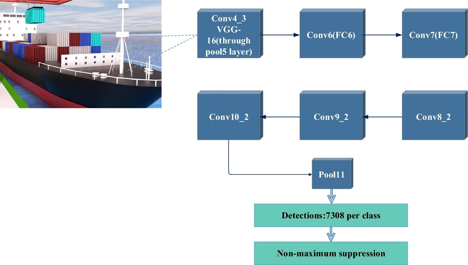
In a recent article published in the journal Scientific Reports, researchers from China proposed an innovative approach to enhance the safety and efficiency of autonomous navigation in port channels. They focused on integrating computer vision (CV) and light detection and ranging (LiDAR) technologies to create a comprehensive perception of the port environment, enabling more accurate collision prediction and optimal path planning for autonomous vessels.
 SSD structure. Image Credit: https://www.nature.com/articles/s41598-024-60327-9
Background
Port channels serve as vital channels for global trade, underscoring the importance of ensuring the safe navigation of ships within them. Traditional navigation systems, reliant on radio detection and ranging (Radar), global positioning systems (GPS), and other technologies, encounter challenges in the complex port environment, including difficulties in achieving high-precision perception and accurate collision prediction.
The integration of CV and LiDAR technologies, also known as laser radar, presents a promising solution. These technologies offer detailed and high-resolution environmental perception. LiDAR facilitates precise distance measurements, while CV enables real-time analysis of visual information surrounding ships, thereby enabling a more comprehensive understanding of their relationship with the environment. However, they also face their own set of challenges, including limitations in adverse weather conditions or dense environments.
About the Research
In this paper, the authors focused on enhancing port navigation safety through the reduction of collision accidents, optimizing waterways, minimizing environmental risks, and ultimately increasing port throughput. To achieve these objectives, they utilized an advanced approach involving various algorithms and technologies.
The researchers employed an advanced path-planning algorithm, a collision prediction model, and a real-time decision-making algorithm. These tools were crucial in ensuring efficient and safe navigation within the port environment. By integrating radar, LiDAR, and image sensor data, a three-dimensional (3D) map of the port channel was created. This map facilitated the identification of other ships and obstacles, enabling better navigation and collision avoidance.
The study utilized an improved rapidly exploring random tree (RRT) algorithm in combination with the artificial potential field method to generate optimal navigation paths. These paths considered vessel dynamics, channel complexity, and safety requirements, ensuring a comprehensive approach to navigation planning.
To predict potential collisions, the authors developed an enhanced faster region-based convolutional neural network (Faster R-CNN) model. This model incorporated K-Means clustering to enhance its adaptability to different types of obstacles present in the port environment. By leveraging these advanced technologies and algorithms, the study aimed to significantly improve the safety and efficiency of port navigation, ultimately benefiting both maritime operations and environmental protection.
Research Findings
The experimental results demonstrated the effectiveness of the proposed approach in enhancing port navigation safety. By integrating visual perception, LiDAR, and the single-shot multibox detector (SSD) algorithm, the system exhibited superior performance in accurately identifying the positions of ships and obstacles. This integrated approach outperformed using LiDAR alone, with relative errors as low as 2.33%.
The utilization of the RRT algorithm enhanced by the artificial potential field method yielded significant advantages over the traditional RRT algorithm. It resulted in a 14% reduction in average path length and a 27% decrease in average time consumption. Moreover, the maximum collision risk notably decreased from 15% to 8%, indicating a substantial enhancement in navigation safety.
Furthermore, the collision prediction model, which incorporated K-Means clustering and Faster R-CNN, surpassed other models such as random forest (RF), support vector machine (SVM), and logistic regression (LR) in terms of accuracy, recall, and F1 score. The K-Means combined with the Faster R-CNN algorithm achieved an impressive accuracy of 92%, a recall rate of 88%, and an F1 score of 90%, highlighting its exceptional performance in accurately predicting collisions. These outcomes collectively showcased the efficacy and superiority of the new technique in improving port navigation safety and efficiency.
Applications
The novel technique has important implications for the maritime industry and port operations. The combination of CV and LiDAR technologies, coupled with advanced path planning and collision prediction algorithms, can significantly enhance the safety and efficiency of autonomous navigation in port channels. This can lead to a reduction in collision accidents, lower environmental risks, and ultimately, an increase in port throughput.
The improved navigation path planning and collision prediction capabilities are particularly beneficial in complex and dynamic port environments, where traditional navigation systems may face limitations. The ability to accurately identify obstacles, predict potential collisions, and generate optimal navigation paths can contribute to safer and more efficient port operations.
Conclusion
In summary, the novel approach proved effective for autonomous navigation and collision prediction in port channels. It successfully addressed the limitations of traditional navigation systems, enhancing navigation safety and efficiency.
As the maritime industry evolves towards greater automation and sustainability, this research could provide a valuable framework for developing next-generation autonomous navigation systems. Moving forward, further research and refinement of the proposed algorithms could lead to even more robust and adaptable solutions, ultimately enhancing the safety and productivity of port operations worldwide.