In a paper published in the journal Scientific Reports, researchers demonstrated the efficacy of using Sentinel-2 satellite imagery and machine learning (ML) algorithms to estimate key parameters essential for efficient grazing management.
Predictive models were developed to estimate pasture leaf forage mass (FM), crude protein (CP), and fiber content by integrating field datasets with satellite images and meteorological data. The models based on support vector regression (SVR) showed promising accuracy, offering the potential for improving precision feeding technologies and decision support tools in sustainable grazing practices.
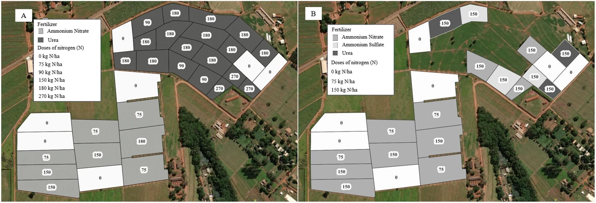
 Distribution of paddocks and their nitrogen fertilization in the study area in (A) from 2016 to 2019 and (B) in 2020. 1 ha = 10.000 m2. The map was generated with the QGIS v.3.28.10 software (https://qgis.org/en/site/). Image Credit: https://www.nature.com/articles/s41598-024-59160-x
Background
Past work has explored the potential of using ML algorithms with Sentinel-2 satellite data to estimate key parameters of tropical pastures. However, challenges persist in accurately estimating these parameters in tropical pastures due to the effects of senescent material and soil background scattering.
Capturing the spatial and temporal variability effectively in tropical ecosystems requires robust models capable of navigating their complexity. Additionally, the cost and complexity of hyperspectral sensors pose practical constraints, necessitating the exploration of alternative methods using satellite data like Sentinel-2. Overcoming these challenges will be crucial for advancing precision livestock farming and sustainable grazing management in tropical regions.
Pasture Analysis Study
The climate is humid subtropical (Aw) according to Köppen's classification, which is characterized by dry winters and warm summers. The soil type in the area is classified as a typical Hapludox with a clayey texture. The research focused on 44.2 hectares of Marandu palisade grass pastures, managed with varying nitrogen fertilization doses from 2016 to 2019 and 2020.
Field data collection involved periodic sampling of FM and chemical composition parameters. Forage samples were collected by clipping all plants within a circular area of 0.25 m2 per paddock and dried to estimate total forage dry matter per hectare. The team analyzed pasture chemical composition, including nitrogen (N) and neutral detergent fiber (NDF) content. The study spanned from January to April each year during the pasture growing season, with meteorological data acquired from a local station.
Remote sensing data collection involved geo-referencing all paddocks and obtaining spectral reflectance from Sentinel-2 multispectral instrument products. The images underwent processing to ensure they were free from clouds and shadows, after which the reflectance values were utilized to calculate vegetation indices.
Models based on SVR and random forest (RF) algorithms were developed using meteorological data, spectral reflectance, and vegetation indices as input features. The model evaluation employed a fivefold cross-validation method due to the unavailability of an independent evaluation dataset. Evaluation metrics included coefficient of determination (R2), root mean square prediction error (RMSPE), and concordance correlation coefficient (CCC). Residual analyses assessed model biases, with statistical significance set at P < 0.05.
Pasture Analysis Findings
This study analyzed field data and Sentinel-2 satellite images from Marandu palisade grass pastures. These pastures were managed under continuous stocking and subjected to varying levels of nitrogen fertilization. Data collection spanned January to April 2016 to 2020, covering the pasture growing season. Models utilizing SVR and RF ML algorithms were developed to estimate pasture FM, CP, and NDF content, incorporating meteorological data, spectral reflectance, and vegetation indices (VI).
The models constructed for estimating FM parameters demonstrated varying degrees of precision and accuracy. Models that integrated vegetation indices (VI) with meteorological data showed moderate to high precision in estimating dry leaf and green FM. Conversely, models relying exclusively on spectral reflectance data displayed lower precision in estimating total FM.
Interestingly, the SVR models slightly outperformed the RF models across these estimations, with no evident prediction bias observed. Models that combined spectral bands with meteorological data achieved the highest precision in estimating CP and NDF content. The addition of meteorological data significantly improved the accuracy of CP and NDF estimation compared to models using only spectral bands or vegetation indices. Notably, the most influential features in the best models were the spectral reflectances in specific bands and mainly red edges, emphasizing their importance in predicting CP and NDF content.
Overall, the findings highlight the potential of integrating satellite imagery and ML algorithms to accurately estimate key parameters in tropical pastures. It is crucial for informed grazing management decisions and sustainable livestock production practices.
Tropical Pasture Challenges
The study underscores both advancements and challenges in estimating critical parameters of tropical pastures through satellite imagery and ML algorithms. One notable obstacle is tropical ecosystems' inherent complexity and variability, which can pose difficulties in accurately capturing spatial and temporal patterns. Additionally, while valuable, reliance on satellite imagery may need to be improved by factors such as cloud cover and limited availability of high-quality data, which could impact the performance and reliability of the developed models. Overcoming these challenges will require ongoing refinement of modeling techniques and data collection strategies to ensure robust and accurate pasture parameter estimation, ultimately enhancing livestock production's sustainability and efficiency in tropical regions.
Conclusion
In summary, this study showcased the potential of using Sentinel-2 satellite imagery and ML algorithms to estimate key parameters of tropical pastures. Results indicated that models incorporating spectral data and meteorological variables outperformed others in predicting forage mass, crude protein, and fiber content. These findings offer promising implications for improving precision feeding technologies and decision-making in grazing management practices.